T-Kartor Iris®

Geospatial Data Management

Request a Demo →

T-Kartor Iris®

Geospatial Data Management

Request a Demo →

T-Kartor Iris®

Secure Geospatial Data Management

Modern Information
Management Environment

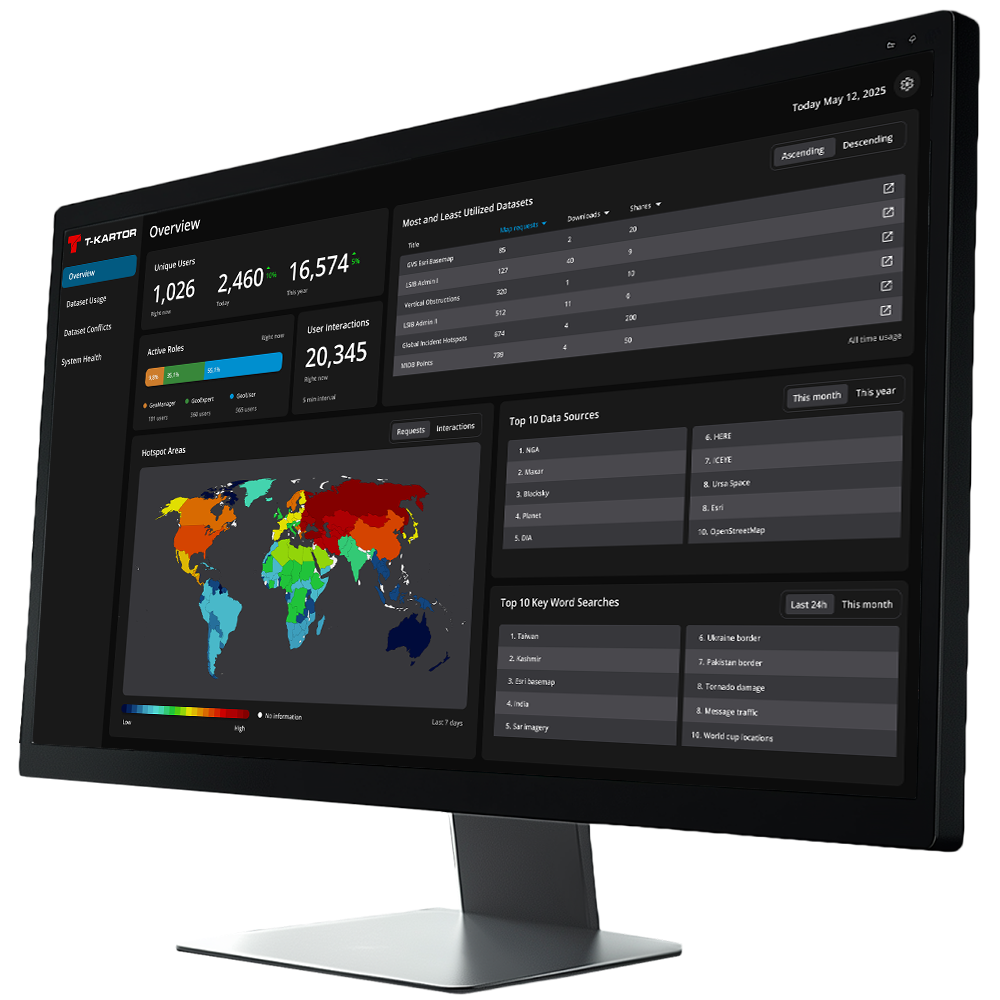
T-Kartor Iris® is a secure, scalable solution for geospatial data management, built to bring structure, control, and insight to complex data environments. Iris allows organizations to collect, organize, visualize, protect, share, and analyze spatial data efficiently, empowering both technical experts and end-users to access the information they need, when they need it.


By centralizing and unifying spatial data across siloed, secure, and open environments, Iris transforms fragmented datasets into a single, trusted source of truth, enabling faster decision-making, interoperability across systems, and mission-critical readiness.

Iris Core Features

Organize

Protect

Visualize

Share

Analyze

Register

T-Kartor Iris®

Add On Packages

Extend Iris with Additional Capabilities

OSM

NATO

ArcGIS®
Add-In

METOC

Work Order
Mgmt

ASPEN

GeoCoder

Web Clients

Iris Core Features

T-Kartor Iris®

Add On Packages

Extend Iris with Additional Capabilities

Value & Impact

Advanced Data Integration

Supports 300+ formats and connects to diverse internal and external data sources, compliant with ISO, NATO, and OGC standards.

Federated Geospatial Catalog

Catalogues, synchronizes, and harmonizes data across departments, platforms, and security levels.

Flexible & Scalable Deployment

Built with containers so it can run on a physical or virtual hardware, in the cloud, or on premises, adopting to organizations of any size.

Flexible & Scalable Deployment

Built with containers so it can run on a physical or virtual hardware, in the cloud, or on premises, adopting to organizations of any size.

Streamlined Workflows

From data ingestion to analytics, Iris® includes ready-to-use modules and automated data processing to simplify complex tasks for both experts and operational users.

Value & Impact

Advanced Data Integration

Supports 300+ formats and connects to diverse internal and external data sources, compliant with ISO, NATO, and OGC standards.

Federated Geospatial Catalog

Catalogues, synchronizes, and harmonizes data across departments, platforms, and security levels.

Flexible & Scalable Deployment

Built with containers so it can run on a physical or virtual hardware, in the cloud, or on premises, adopting to organizations of any size.

Comprehensive Security Framework

Protects data across multiple security levels, controlling access and ensuring compliance with IT and cybersecurity protocols.

Streamlined Workflows

From data ingestion to analytics, Iris includes ready-to-use modules and automated data processing to simplify complex tasks for both experts and operational users.

Why Iris®?

Iris® provides the geospatial data backbone for modern organizations. It ensures the information is always accessible, interoperable, and secure, enabling teams to act with confidence, support operations, and unlock the full value of their spatial data, whether for defense, public safety, or any mission-critical scenario.

Why Iris?

Iris provides the geospatial data backbone for modern organizations. It ensures the information is always accessible, interoperable, and secure, enabling teams to act with confidence, support operations, and unlock the full value of their spatial data, whether for defense, public safety, or any mission-critical scenario.

Request a Demo

Schedule a meeting with our experts to discover how our Iris® platform can be a benefit for your organization.

Request A Demo (Iris)